Traffic Management
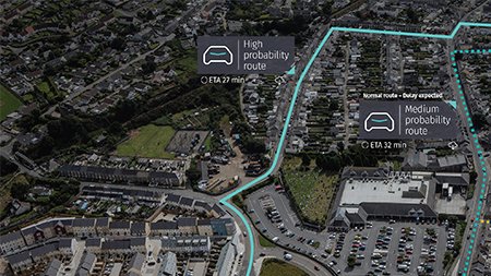
 In the United States, agencies leverage real-time and historic data for advance traffic management, to increase driver safety, reduce congestion and manage big construction projects. Before widespread connectivity, many agencies installed fixed road sensors, but these sensors can be expensive to maintain over a time. Today, GPS probe data is a cost-effective solution for agencies to expand their network coverage and can complement fixed sensors.
HERE collects more than 100 billion probe points monthly in real-time to see how people move through the city. This real-time insight gives cities a better understanding of the current road conditions and allows them to monitor changes over time.
Real-time data is crucial in situations that require an immediate action, while historic data improves planning and performance management. Infrastructure operators leverage historic data to identify the most congested areas, understand traffic bottlenecks and determine the right places to invest their resources. With realtime and historic data, our partners create data-driven solutions.
[box type=”shadow” ]The core of nearly every solution is citizen engagement, data scalability and collaboration. It is an exciting time in transportation as we are just at the beginning of this transformation in society.[/box]
Vehicle Safety and Mobility
In the automotive industry, almost every manufacturer operates on its own, but we are starting to see more collaboration. Today, three automotive companies share vehicle sensor data with HERE to improve safety and efficiency on the road. Vehicle sensor data, such as the hard-braking activity, road friction, fog lights and wiper activity, is the next generation of crowdsourced data.
When we aggregate and analyze vehicle sensor data, we can send drivers important insights and safety hazard alerts. For example, if several cars detect slippery road conditions, we can warn other vehicles before they reach the area. Vehicle sensor data can also warn traffic management about a dangerous or hazardous situation that needs their support.
On-Demand Mobility Options
The connectivity and data cities use to improve mobility is also helping travellers and commuters explore multimodal transportation options. Commuters use real-time information from government agencies and private companies to understand their options across all forms of mobility: driving, public transit, walking, biking, ridesharing and car-sharing. Depending on the user’s location and time of day, the most efficient solution could be a combination of two or more modes of transportation, like biking to public transportation.
Whether an app recommends a single form of transportation or a multimodal solution, the request generates new data that improves the system. Routing data allows the traveller to make realtime decisions, GPS probe data informs city operations about demand and together they support planning.
Data-driven Solutions in Action
In India, the challenges are immense, but so are the opportunities. In the state of Rajasthan, we have enabled the government to create a unified data platform to increase collaboration between agencies and give citizens better access to information. Often silos within cities create barriers to addressing public safety and improving public services. Citizens can also use the platform to understand their location better and to make location-specific decisions based on nearby facilities, such as police stations, educational institutions, medical facilities and financial institutions.
To help police and emergency vehicles serve the 200 million people living in Uttar Pradesh, we powered Dial 100 emergency and safety services to effectively deploy officers based on their location and real-time traffic conditions. The police department relies on location data for route calculations and to understand which vehicles should be deployed to the incident. Activated in 2017, the police supported more than 600,000 cases in the first 100 days and saved 800 lives in 2017.
As we think about a connected world, it’s not about collecting data for the sake of having data. It’s about finding new insights and making more intelligent decisions. To do this, we need to identify the problem cities are trying to solve, determine the type of data needed to solve that problem and collaborate with the relevant organizations to deliver a solution.