[box type=”shadow” ]
Monali Shah, Director, HERE Technologies highlights smart city and transportation trends seen around the world and shows how we can solve transportation challenges by implementing new technology and harnessing the power of data.
[/box]
 Visiting India throughout my life has given me an opportunity to see amazing transformations, especially over the last ten to fifteen years. Every visit allows me to see infrastructure improvements, new investments in mobility and increased connectivity.
Connectivity is increasing around the world and by some estimates, we will have more than 200 billion internet-connected devices by 2020. As a result, we are experiencing an explosion of data from smart phones, smart cities, connected vehicles and new businesses within the on-demand economy. We are becoming a connected world in motion.
The Challenge and Opportunity
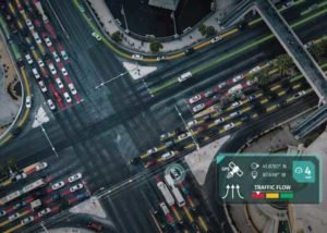
 The challenge for leaders is how to leverage these new data sources to solve our biggest problems, like congestion. Congestion is a major problem for commuters and it compounds into environment, economic and safety issues. Air pollution increases, productivity and mobility decrease and lives are lost.
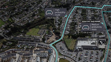
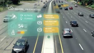
To combat the world’s largest problems, leaders need to harness the power of data. While human and machine generated data is exploding, the richness is typically hidden due to volume, velocity and variety of data. That is why we need to look at the common element across data sources, location. With location at the core, we can combine different data sets and use analytics and artificial intelligence to interpret the data around us.
However, much of today’s data is still in silos: vehicles, products, personal devices and infrastructure packages. Data silos restrict our ability to draw connections and solve problems effectively, but HERE Technologies is breaking down silos across the public and private sectors.
Collaboration is critical and no government, company or individual can solve major problems alone. Through collaborations, our location intelligence transforms big data into big insights that solve real challenges.
To help increase collaboration and enable easier sharing of data, we have created the Open Location Platform that allows the public agencies, industries, and companies to merge data, generate insights and solve challenges. This creates new connections between industries, organizations and across borders.
The foundation of OLP is the Reality Index™, a digital representation of the real world, organized by location and time. It connects essential details like road networks, businesses, addresses, landmarks, bus routes and off-road elements.
As one of the world’s leading digital map makers, our map covers more than 200 countries and is on-board more than 100 million vehicles. To ensure the freshness, richness and accuracy of our data, we capture more than 28TB of location data daily and process billions of probe points every month. With this magnitude of data, we deliver real-time products and address transportation challenges around the world. Cities use this type of data to enrich the information they collect from sensors and existing other technology.
In each market, we first consider the most pressing needs and priorities. Then we assess the different types of data available to close the loop between vehicles, agencies and travellers.