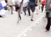
 Pedestrian infrastructure is an integral part of road design but is seldom given the required attention in Indian cities. Considering almost 32% of trips in Chennai are made on foot and pedestrians account for a high percentage of the fatalities on Chennai?s roads, the Corporation of Chennai and the state?s Road Safety Committee need to take necessary steps to safeguard them. The city?s roads are in a constant state of despair because of the increased vehicular traffic. Pedestrians suffer the most as there is constant encroachment of pavements and the periodic maintenance of essential utilities both underneath and on the roads means that walking space is even more limited.
Gradually, more people have been giving attention to the issue of pedestrian infrastructure. There have been instances in the city where perturbed residents have built their own roads as the authorities did not heed to their regular complaints. In the recent past the print media has also woken up to the lack of civic infrastructure in the city and has been campaigning about these issues on a regular basis but has not been able to make an impact as it requires perseverance. Transparent Chennai (TC) ? a community data and planning project housed at the Institute for Financial Management and Research ? has tried to create a public participatory approach to bring about change at the neighbourhood level.
In September 2011, TC experimented with a more participatory planning process in ward 176 in Besant Nagar as the Municipal elections were approaching. TC organised residents and volunteers to survey the ward, and found that the ward lacked pedestrian infrastructure, public toilets and good solid waste management. TC used the data to create a report which could be used by the people to demand better infrastructure. The design and reports were submitted to the councillor after the election and two follow-up meetings were held, including one that the MLA called. Another similar exercise in Ward 57 has led to monthly review meetings in which the councillor meets with residents of low-income communities in the ward to report on progress on problems like toilet maintenance and garbage pickup.
The youth has to be vigilant and participate in the betterment of their neighbourhoods. Residents should demand a walk-able neighbourhood as every journey starts and ends with a walk.
More recently, TC worked with residents of wards 167 and 164 in Nanganallur which became a part of the Corporation in October 2011. These wards did not have any secondary data on the pavements, so the residents had to survey and create the required data. The enthusiastic residents and the active RWA members regularly attended the survey sessions and the councillor has been very supportive of this initiative. The final report for these wards are being made after which the design implementation strategy would be work out. For the above case studies TC has adopted a robust methodology which involves the following steps:
 Community Outreach: TC usually approaches the RWAs (Resident Welfare Associations) and the CBOs (Community Based Organisations) working in the neighbourhood and explains the nuances of walk-ability and its adjunct benefits. Since most of the city is going through an infrastructure up-gradation phase, most roads are in a hideous condition. However, citizens could use this time as an opportunity to think about better design ideas, ideas that could help roads respond to the surrounding land-use. Through this process, the citizens are made to understand the benefits of a good walking environment and its link to increase in use of public transport. The benefits of decongesting the streets, the reduction of carbon emissions and the creation of a healthier and safer environment with greener surroundings are also explained. TC also discusses how good pedestrian infrastructure can create equality in the use of public spaces, and residents are sensitised about the value of having street vendors, who have become an integral part of the economic and social environment of our neighbourhoods. TC meets the community a few times during this initial stage, both to gauge their interest and to understand the extent of their knowledge about footpaths and other pedestrian issues.
Surveying, Mapping and Data Collection: If data about a particular area is not comprehensive (which it is not in most cases) TC asks the residents to volunteer for surveying roads by using its toolkit. A user-friendly surveying toolkit has been developed, comprising paper maps to mark obstructions and spatial information, as well as a survey using a questionnaire consisting of both quantitative and qualitative questions about the infrastructure and motorist behaviour in the concerned areas. The surveys are mostly done on Saturdays, Sundays and government holidays. After the residents are briefed about the process, groups of two to three are formed who survey the selected roads, accompanied by trained volunteers from the TC team. This survey is led by the residents as they are most aware of the issues in their neighbourhood. Their involvement in creating the data will hopefully enable them to exercise ownership over the data, and encourage them to use the data for pushing for changes and for holding councillors accountable for improvements. The paper map is a high-resolution black and white print of the satellite image of a selected road. If the road is long, the survey is divided between multiple groups such that the length of the roads to be surveyed by each group does not exceed 250-300 meters. The extent of each survey area is often indicated by landmarks and intersections.
Digitisation and Analysis: Once the survey is done, the TC team digitises the information gathered by using GIS (Geographical Information System) software (either Arc GIS or QGIS) and analyses the data. This analysis helps in identifying key problem areas or patterns. The problems identified from the survey can range from discontinuity or non-existence of the footpath to safety issues on the street due to inadequate lighting and many others. The survey also helps in identifying encroachments on the footpath by abutting shops, vendors, utility boxes, trees and vehicles. It also helps in determining the locations where public urination happens (which is often due to lack of public conveniences in the vicinity).
 Design workshop for residents to express their views: All this analysis is collated in the form of maps and graphs and is presented to the community in a meeting. In Nanganallur, besides these findings, the TC team also explained the components of good footpath design, such as the necessity of having a clean and even surface that is durable and is made of a non-slip material, the standard height and width of footpaths in particular kinds of areas, and how to build infrastructure for providing access to those with disabilities as well. Footpath design can be divided essentially into three zones: the frontage, pedestrian and the furniture zone. The furniture zone is used for services like parking, street lights, street furniture, vendors, utility boxes, trees etc. The width of the frontage and pedestrian zone depends on the surrounding land-use but should be at least 1.8m as per the IRC 103-2012 guidelines for pedestrian facilities. The series of slides in the presentation improved the understanding of the residents and led to informed suggestions and ideas. Everybody agreed that wider and more usable footpaths were needed.
Design Finalisation: The design workshop helped residents to construct an image of how they envisaged their streets and the design was finalised taking into account suggestions given by the community. The workshop had a mixed age group of participants from school children to senior citizens. Participants were divided into groups of four or five and given printed copies of digitised road sections of key problem areas ? places of high pedestrian and other traffic. They were also given small models of trees, utility boxes, vendors, traffic calmers, and other street features and asked to use these to design an ideal street for these problem areas. Their inputs and design solutions are being made into a comprehensive and cohesive report which will be further discussed with the councillor and concerned ward officials for implementation in another meeting in which the residents are also present.