 Endowed with natural beauty and hilly terrain, the state Mizoram shares 404kms long border with Myanmar (Burma) in the East, and 318kms long with Bangladesh in the West making it a strategic location for international trade. The hills are a perfect holiday destination. However, when it comes to urban mobility, the challenges are quite enormous. With special focus to the capital city Aizawl, Lalmuansanga Ralte, Under Secretary-Urban Development & Poverty Alleviation Department, Government of Mizoram delves into some of the urban mobility challenges surrounding hill cities.
Aizawl has a resident population of 293416 (2011 census), located north of the Tropic of Cancer in the northern part of Mizoram. It is situated on a ridge 1,132 metres (3715ft) above sea level, with the Tlawng river valley to its west and the Tuirial river valley to its east. It has a mild, sub-tropical climate due to its location and elevation. Under the Köppen climate classification, Aizawl features a humid subtropical climate (Cwa) but very rainy. In the summer the temperature ranges from 20–30°C (68–86°F), and in the winter 11–21°C (52–70°F). The State also shares its inter-state borders with Assam (123kms) in the North, Manipur (95kms) in North and with Tripura (277kms) in the North-West.
 Like any other state in the country, there is an explosive increase in vehicle numbers in the North-Eastern States as well. Recent survey indicates that there are as many as 2.7 registered vehicles in the region. The share of each State is shown below.
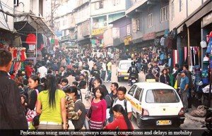
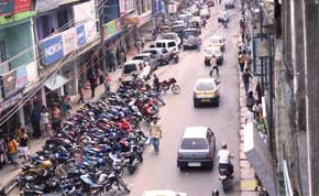
In hill cities like Aizawl, mobility issues and challenges are of great concern because hill cities are characterized by narrow roads with high to steep gradients and several number of acute bends and curves. Due to its topography and terrain, there is acute shortage of land and open space, which makes urban transport planning much more challenging than the plains. The roads are narrow, and in some places steep. The roads in Aizawl city, in general, can be said to be of three types in terms of their width; the widest is about 10mts, next would be about 8.5mts and the narrowest one is 6.5mts wide. The width of the road does not permit planning for a MRTS or BRTS. Unlike plains, after every hundred feet or so, there are bends and curves, and the road is shared by all types of transport modes. In recent years, there has been an increase in the number of two wheelers adding to the congestion. In the absence of proper parking spaces, and vehicles are parked on the roadside.
Physical Network
As with most small to medium sized towns, issues related to urban transport in Aizawl city can be divided into two categories. Firstly, there are issues which necessitate actions to catch up with the accumulated shortfall in provision of transport supply to bring the city to a minimum acceptable level of service quality and overall mobility. Secondly, to arrest any further accumulation of such backlog, it is imperative to put in place a plan and process to ensure future development of transport infrastructure in line with overall growth. These two points need strategic and calculated approach. There are a large number of bends and curves; geometrics are poor in terms of angles and gradient. Almost all roads coming from any direction converge to the city centre. In addition to this, there are lack of road hierarchy, which means there is no separate arterial road, sub-arterial road, collector or local roads. This is also attributed to poor planning and other constrains due to slopes in the terrain. If there had been a proper road hierarchy as in the plains, the circulation of vehicles and human traffic in Aizawl would have less road congestion as traffic capacity distribution could be enhanced.
