Congestion Mitigation Strategy for Chennai by Evaluating the Urban Access-Controlled Road System
The space available along the water courses of Chennai can provide an effective alternative to the present options of diverting and disbursing traffic. This will help in relieving the internal roads of congestion.
Management of traffic on major urban road networks in India is bec oming increasingly challenging. Success in reducing traffic congestion requires not only tackling it on multiple fronts with strategies, but also the transportation agencies, businesses and the public cooperating with each other. We need to look at a long term strategy. Based on detailed study and modelling of traffic using the software CUBE and also based on availability of land, the potential for exclusive urban access-controlled roadways in Chennai is examined here in detail.
Growing traffic congestion is one of the most significant and pressing problems in urban India. Increasing affinity to personal vehicles has not only resulted in congestion in metropolitan areas but has also become a universal problem, spreading to smaller urban and rural locations. Congestion affects the movement of people and the flow of goods to the market. It affects quality of life, energy consumption and the environment, including air quality. As India’s economy grows, congestion on urban roads will only worsen. A critical challenge is to use a variety of practical and relevant congestion mitigation options in an appropriate manner. While promoting public transportation should be the top priority, expansion of road network where it is grossly inadequate is inevitable. In particular, high-class roads with capacity for moving greater volumes at higher speeds need to be thought of for major cities. These can cater to the longer trips, thereby relieving congestion on surface streets.
The objective of the study reported in this article is to evaluate the benefits of access-controlled road corridors in urban scenarios in India, taking Chennai as a case study. Only a selected set of corridors were considered.
Methodology
In order to achieve the above objective, a framework of methodology as shown in Fig. 1 was developed. Network data on links, nodes and zones along with O-D (origin-destination) trips and link volume data were collected. These were input to CUBE 5 to get the coded network for analysis. Proposed scenarios of access-controlled road systems were superimposed on existing road network. The peak hour vehicular O-D trips were then assigned to the coded networks to get the link loads. From link loads, travel times, v/c ratios, etc., were determined. This was done for base (existing) scenario as well as the proposed scenarios. Based on the outputs of Measures of Effectiveness (MoEs), the benefits of various scenarios were evaluated.
The proposed alignments for the various corridors were chosen after reviewing the O-D patterns and speed delay survey results. Also, the existing and proposed land use pattern of Chennai Metropolitan Area developed under the master plan of Chennai for the year 2026 and the land availability were considerations in the selection of corridors. In addition, these alignments also connected major traffic generators and attractors.
Proposed Alignments for Access Controlled Roads
The following five alignments, with a total length of 91km, were identified for the study. The corridor-wise details of the alignments are as follows:
i) Adyar – Kathipara Junction – Airport, along Adyar River
ii) Along Inner Ring Road (IRR)
iii) Port Trust – Maduravoyal along Coovum river
iv) Coovum creek – St. Thomas Mount (along Anna Salai)
v) Tiruvottiyur – Neelankarai (along Beach Road and ECR)
Based on the above alignments, the following scenarios of elevated access controlled corridor systems were generated.
Elevated road:
1) On Anna Salai only
2) On Anna Salai and Coovum river
3) On Anna Salai, Coovum river and Inner Ring Road (IRR)
4) On Anna Salai, Coovum river, IRR and Beach Road ECR
5) On Anna Salai, Coovum river, IRR, Beach Road-ECR and along Adyar river
These scenarios were then evaluated using the software,
considering each scenario one at a time.
 The proposed corridors being access-controlled, provision needs to be made for the vehicles to transfer from these to the surface streets and vice-versa. These can be facilitated through interchanges. The locations of these interchanges were carefully identified considering factors such as existing major intersections, land availability, etc.
Scenario Analysis
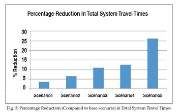
The above scenarios were analysed through the CUBE 5 Base programme. Data pertaining to each of the scenarios were fed into the programme and the output was evaluated through selected MoEs. A limited number of these MoEs are shown below in Fig 3.
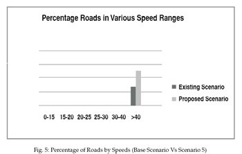
The figure shows the percentage reduction in total system travel t imes for all the scenarios, compared to the base/existing scenario. Scenario 5 yields the highest benefit of about 26% reduction. In terms of V/C (Volume to Capacity) ratios, figure 4 highlights how Scenario 5 brings about decongestion of (existing) congested links; further, higher percentage of roads/links now fall under V/C ratios of 0.60 or less, signifying better level of service. Finally, figure 5 illustrates how the percentage of roads with >40 km/h goes up in Scenario 5 while the percentage of roads falling in lower speed ranges drops.
The study analysis shows that the scenario having elevated access c ontrolled road corridors along all the proposed alignments (Scenario 5) is the most beneficial since it yields significantly high savings / benefits in terms of (1) total system travel time reduction, (2) reduction in O-D travel times, (3) V/C ratio reductions (decongestion of roads), and (4) higher speed ranges, as compared to all other scenarios. The creation of such a high class network will also decongest the surface streets by shifting significant number of trips to the elevated corridors.
The creation of such a high class network will also decongest the surface streets by shifting significant number of trips to the elevated corridors. This, in turn, will facilitate speedier movement of buses. This may also open up opportunities for expanding/enhancing pedestrian walkways and bicycle tracks.
Thus, the crux of the study reported in this article is that Scenari o 5 [access-controlled road systems along Anna Salai, Coovum river, IRR (Inner Ring Road), Beach Road-ECR and along Adyar river Parallel to Sardar Patel Road] was the most attractive scenario among all the scenarios studied. The key findings are:
- The overall total system travel time in the network reduces by 26% (as compared to base scenario)
- Travel times between major O-D pairs reduce; the reduction is about 40% for O-D pairs with travel times of more than 60 minutes
- Percentage of roads with V/C ratios greater than or equal to 0.80 reduces from about 47% to about 29%, signifying significant decongestion
- Percentage of congested roads (speed <30km/h) will also go down from about 57% to about 37%
The creation of such a high class network will also decongest the surface streets by shifting significant number of trips to the elevated corridors. This, in turn, will facilitate speedier movement of buses. This may also open up opportunities for expanding/enhancing pedestrian walkways and bicycle tracks. The secondary benefits of the above proposal will be reduction in fuel consumption, pollution and accidents.
However, it is suggested that further feasibility analysis be taken up before considering adoption of this strategy. The above analysis can be performed considering future scenario
for which the travel benefits of various scenarios can be expected to be even higher in the context of growing travel needs of people and exploding vehicle population in urban areas. Further, a detailed economic analysis of implementing such infrastructure projects can also be taken up. These will be valuable to decision makers.
Rahul Tiwari Senior Manager (Planning)
DDF Consultants Pvt Ltd.
(Rahul Tiwari has five years of research and consulting experience in transportation planning, traffic engineering, and public transportation. Formerly a Research Associate with IIT Madras, he was involved in the Transportation and Pedestrian Master Plan for the Indira Gandhi International Airport, New Delhi).
(The author wishes to acknowledge his gratitude to Chennai Metropolitan Development Authority and Wilbur Smith Associates).
 TrafficInfraTech Magazine Linking People Places & Progress