 Where all have you implemented the technology?
Our solutions are essentially location agnostic. We have worked on projects across the length and breadth of the country – from J&K to Kerala, Gujarat to Manipur. The terrain has spanned the whole spectrum from the rugged Himalayas and Western Ghats to the flat Cauvery Delta.
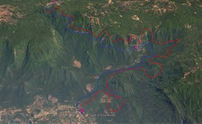
We designed an optimal alignment for an additional rail line on the Castle Rock – Kulem section in the ecologically sensitive Western Ghats. This is one of the most challenging railway projects in the country. The ground level drops over 500m over the 26km existing alignment. The line has very steep gradients and sharp curves and hence, severe running constraints. We were able to improve the gradient and curves and reduce the tunnel requirements.
In another instance, we were able to correct a 25km alignment plan in a matter of hours using our technology. Several months were lost in a fruitless
field survey before this problem was posed to us. We have seen cases where major river crossing sites have been missed in ground surveys, while the same was easily identified by terrain model processing.
We have helped an entrepreneur identify a suitable site for his miner water bottling plant. We enabled a large infrastructure developer identify a site for commercial development, which required a study of a 200sq km corridor, in a matter of weeks. The solution included a spatial analysis of land use and pricing patterns in the corridor and was a powerful decision support system for the management.
There have been interesting applications in other sectors. Consumer banks have used our solutions to identify spatial patterns in loan default, locate ATM sites and analyze effectiveness of credit card sales campaigns. An IT company was able to generate substantial cost savings in employee transport though intelligent routing and scheduling of its bus fleet.
The customer profile and project experience is diverse. What is common, though, is a rigorous approach to problem definition and the intelligent use of data and software.
What are the problems/challenges in integrating geo-spatial products/ systems with other systems?
The integration of geo-spatial products and systems is not the crux of the matter. The real challenge, in our opinion, is for potential users to develop absolute clarity on the decisions that they need to make in problems where location or spatial attributes are important. User requirements are paramount. The data, process and system specifications are just derivatives.
In traditional engineering problems we find that requirements lack necessary details. The desired traceability between requirements and design proposals is missing. In a highway project, for example, there are several studies that are carried out – traffic, geotechnical, drainage, road inventory, pavement condition etc. Consultants generate design proposals for road geometry, service roads and bypasses, bridges, toll plazas, wayside amenities etc based on the findings of these studies. Design problem solving is a cooperative activity which requires communication among different groups, each working on a sub-problem with different information requirements and domain knowledge. We will have more effective outcomes if this is visualized as an information processing activity rather than as a set of tasks for generating engineering drawings. Geospatial analytics firms that also have engineering domain knowledge are best equipped to deal with this challenge.
What are your future plans in this sector?
The infrastructure sectors, especially transportation, water resources and urban development, hold great promise for us. We will both increase the scale of operations and widen the scope of our services. We seek to offer more end-to-end solutions without losing focus on our core strengths which are data analytics, consulting approach to problem solving and algorithms. For the Railways, we now do complete feasibility studies. Besides route selection and alignment design which are engineering problems, we undertake traffic studies, prepare project cost estimates and financial viability reports. The pace of technology change is only accelerating. Data acquired from Lidar, drone systems and sensors require huge data handling and analytics capabilities. These will, undoubtedly, be new opportunities for us.
Omega Analytics was one among fifty recipients of a grant award, selected from over 18000 teams across the country, in the 2015 Power of Ideas programme organized by the Dept. of Science & Technology, Economic Times, Reliance Jio and IIM Ahmedabad. The Power of Ideas is one of the largest entrepreneurship development programmes supported by the Government of India.