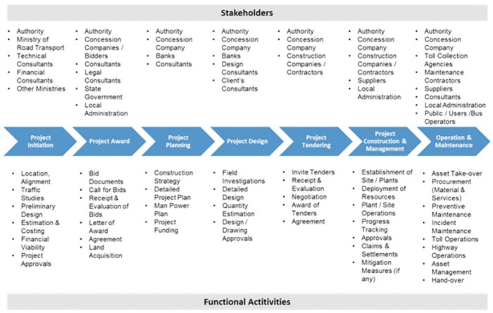
Potential Technologies and Deployment Opportunities
Technology has always been a catalyzing agent in enhancing the efficiency in any industry and Highways is no exception. With growing emphasis on development of infrastructure for placing the nation?s economy on growth trajectory sets the stage for deployment of IT for effective and efficient delivery. Potential technologies which were deployed in highways across the globe include
 ? Positioning Systems (GIS/GPS)
? CAD Systems including 3D/4D visualization systems
? Laser Technology
? RFID Technology
? Process Automation Systems
? Machine Automation Systems
? Database Management Systems
? Web-enabling Technologies
? Communication Technologies
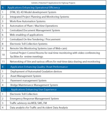
Regardless of technology, based on the effect, IT applications in Highways can be categorized into three segments i.e., those enhancing
? Operational Efficiency ? targeted at eliminating/minimizing time delays and cost overruns.
? Asset Performance ? focused on increasing the service life of assets.
? User Experience ? aimed at providing information to users
IT applications developed for highway projects using specific technologies are reviewed from the above perspective based on their deployment stages in the project life-cycle (Exhibit 2).
Project Initiation
During the Planning Stage, Feasibility Consultants are employed who collect preliminary data for evaluation of project feasibility. During this stage, satellite imagery/remote sensing data can be used for development of (3D) terrain models. Use of GIS/GPS hardware-cum-software can speed-up the development of 3D by creation of DTM with minimal human resources. This is far superior to the current physical surveying practices adopted deploying large man-power with time consuming process with limited control on quality. Manufacturers of these positioning systems such as Trimble, Topcon are also offering latest surveying systems such as Robotic Total Stations and 3D laser scanners. LiDAR (Laser detection and Ranging) can be used to produce accurate surveys and models which can be used for better estimation of quantities.
Data since the conception stage till the end of life cycle should be digitized according to a standard format and made available to stakeholders, which would get metamorphosed during different stages of the project and helps enhance the quality and speed of execution
One of the key contributors to the delay in highway projects today is approvals and land acquisition. Deployment of a web-based centralized work-flow management system by the authority for submission, processing and approval of applications for highway projects can act as a single window clearance system. This can greatly enhance transparency and accountability amongst the stakeholders.
Project Design
 Models developed during the feasibility stage can be shared to the bidders for their evaluation which can save large amounts of effort and cost. Successful bidders can use the above as the base and develop 3D and 4D models for visualization and scheduling. 3D models used in conjunction with construction work progress schedule are called 4D models which facilitate the design change feedback, material fabrication/procurement, constructability reviews, quantity tracking, as-built documentation, public relations and schedule optimization.
During design stage lot of data is collected as part of field investigations. Use of properly calibrated equipment for collection of data and storing of the same in a standard format after processing in a Centralized Database can enable access of the same by different stakeholders involved in project design and approvals.
During design phases, use of integrated CAD system can enable multi-disciplinary teams such as geo-technical engineers, structural engineers, pavement engineers, and electrical engineers etc., to share data across disciplines for perform engineering analysis/modeling and develop drawings. Collaborative framework can help in diagnosing constructability issues, assessment of material requirements and availability analysis at design stage minimizing the execution delays
Use of laser based Road surface profilers for pavement quality roughness and related measurements offer accurate, rapid and real-time measurements.
Use of Rolling Weight Deflectometer (RWD) along with spot laser for measurement of deflection in place of Falling Weight Deflectometer (FWD) can enhance the quality and hasten the process.
Laser based bridge deflection system can reduce cost of load ratings and also provide accurate real-time measurements. The system uses frequency modulated laser to measure bridge deflection from a range of up to 30m. Computer controlled scanning system controls the laser and allows the system to scan a large area of structure. This will avoid the need for accessing the remote areas of the bridges installation of sensors and instruments, surface preparation
Independent software such as Road Estimator and CalQuan are adopted by some firms for quantity estimation in highway projects.
