Construction & Project Management
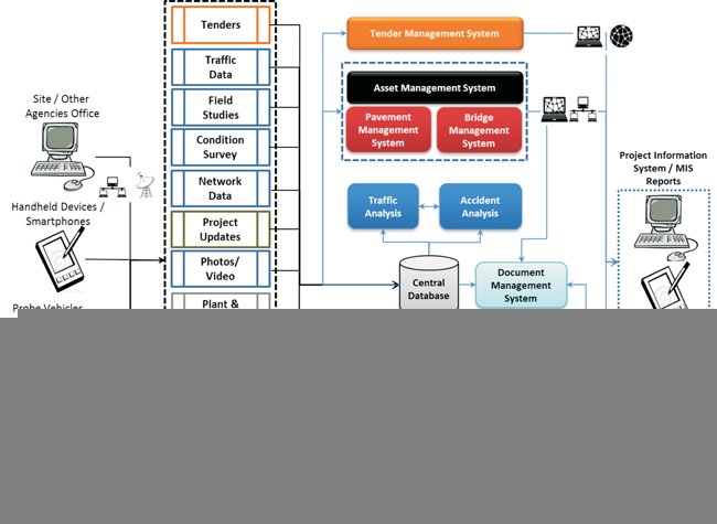
The key activity for project management team during construction is to keep accounting of Time, Material, Manpower, and Machinery. Handheld Devices/Smartphone and supporting applications can be used for field data collection, communication and monitoring of performance. These devices can enable multimedia data capture ? voice, pictures and video.
With multiple systems in place it is essential to pre-define and standardize the data and their formats of collection and inputting to the database which will enable smooth interfacing/exchange of data between multiple systems/stakeholders
Use of Project Scheduling and Monitoring software such as TILOS a state-of the art tool which combines both time and distance in one platform can greatly enhance the process of scheduling the construction activities in an integrated matter and progress monitoring.
Centralized Document Management System with web-enablement shall facilitate sharing of design details and shop drawings in electronic form expediting the review by multiple stakeholders and subsequent revisions/corrections and Approvals eliminating the limitation of geographical boundaries. This would also facilitate managing RFI?s, Change Orders, processing payments, handling disputes/claims etc., ACONEX is one of such most popular implementations in large projects.
Web-based Project Monitoring systems integrated with handheld devices for data capture and data analytic applications can ensure uniform information sharing across stakeholders. Also facilitates root-cause analysis for delays and non-performance of people, processes and machinery and decision making.
Uniform and integrated deployment of technology in various stages of highway project life cycle can bring in operational efficiency, improve asset performance and give its users & stakeholders a better experience
Specific applications such as plant automation, inventory management also can be integrated on a common IT platform to add
Video Conferencing and deployment of Mobile Vehicles equipped with Cameras can allow senior management to view the real-time progress and communicate with team and reduces the physical travel needs. Development of wirelessly networked remote construction sites, offices of employer, contractor, consultant and authorities to provide access to database and enable contribution of data in real-time.
Highway Maintenance Management
 Since the infrastructure capacity cannot be enhanced commensurate with the growth in demand, efficient use of the same is the imperative which necessitates proper maintenance and management of the assets which is be possible without deployment of IT tools. Design life and performance monitoring of asset and development of a comprehensive rehabilitation policy is the key to effectiveness.
A strong database of the inventory containing salient features of the materials used, type of structures, locations, and details of past inspections, assessments and repairs and rehabilitations carried out is highly essential for proper maintenance and management of highways.
Deployment of a Comprehensive Asset Management System will enable development of strategy, selection of alternatives and timing of repair and maintenance activities. Project/section specific asset performance models developed considering traffic, age, initial conditions were found to predict the performance of pavements more accurately. Maintenance strategies thus developed type and cause of distress allowed for timely and appropriate maintenance to ensure long service life of the asset.
GIS/GPS based systems integrated with handheld computers / Smart Phones for data updation and monitoring can be deployed as part of Asset Management System.
Bridge Maintenance Management System developed by CSIR-CRRI is one of the potential software for the purpose.
Safety Administration
Deployment of IT tool for collection and analysis of accident data which can be used to enhance the safety along highways. Building the geo-referenced (GIS/GPS) database of accidents with pictures, videos along highways can be used for identification of black-spots and conducting root cause analysis for development of mitigation measures. The information can be shared with
? designers, contractors and operators to enable them to design, build and operate safer highways
? regular commuters on the highway through truck associations, commercial taxi / bus operators for enhancing safety awareness
? with police and insurance agencies
? users planning their trips along the specific corridors could
