
Page 34 - TT Aug-Sept pdf for digital
P. 34
ITS
analyses will also provide insights
into the locations that are likely to
experience increased congestion
due to the roadwork, enabling
operational managers to make
informed decisions about traffic
diversions.
What-if analysis around natural
disasters is another transport model
use case. If the competent authority
has access to a transport model
and information about the spatial
distribution of population, transport
models can be used to work out how
design and performance parameters. and interfaced with micro- fast one can evacuate the population
Such simulation models often involve simulation software using APIs. when a disaster strikes a particular
custom software modules that The model was used to determine location. Decisions about where
emulate the ITS system working in the performance parameters of to move the evacuated population
tandem with established simulation the proposed ITS design under also can be made with confidence
software through their APIs. various traffic conditions before it based on model supported analysis.
was implemented. DartCharge is Such model-based analysis also
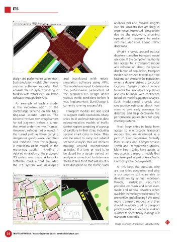
An example of such a model
is the microsimulation of the currently running successfully. can provide estimates about how
DartCharge scheme on the M25 Transport models are also used soon to give early warnings for
ring-road around London. The to support traffic operations. Many disasters and help determine the
scheme involved removing barriers cities build and maintain up-to-date performance parameters for early
for toll payment before a tunnel microsimulation models of traffic warning systems.
that went under the river Thames. control regions consisting of a group Most large cities in India have
However, vehicles not allowed in of junctions in their cities, including access to macroscopic transport
the tunnel such as those carrying several smart cities in India. They models that are developed as a
dangerous goods were identified can be used to carry out what-if part of Comprehensive Mobility
and removed from the highway. scenario analysis that aid decision Plan studies and Comprehensive
A microsimulation model of the making around maintenance Traffic and Transportation Studies.
motorway section including a activities. If a lane or road is to Many Smart Cities have access to
detailed emulation of the proposed be closed for a certain period, an microscopic transport models that
ITS system was made. A bespoke analysis is carried out to determine are developed as part of Area Traffic
software module that emulated the best time for it that will result in Control System deployments.
the ITS system was developed least disruption to the traffic. Such
All this begs the question, why
are our cities congested and why
is our country still vulnerable to
devastation by annual monsoon
floods, landslides, recurrent
potholes on roads and other man-
made and natural disasters when
available technology can be used for
prevention and planning? We need
more transport models and they
should be widely used by transport
professionals and decision makers
in order to scientifically manage our
transport networks.
TT
Image Courtesy: Simulation of Urban Mobility
34 TRAFFICINFRATECH / August-September 2024 / www.trafficinfratech.com