Problems noted at the junction
 The team noted that to tackle the problems the roads posed, PCMC had already made some interventions at the junction. One was putting up a jersey barrier in the middle of the junction to stop the drivers of vehicles approaching the junction from turning in any direction they wanted. However, despite this intervention, the private vehicle owners continued to turn in any direction they wanted. Also, pedestrians and the motorised traffic – did not respect signal lights. “As the green light – for pedestrians – is often too short and their waiting time too long, they often ignored the signals. Moreover, the crossing distances were long. Yet, no pedestrian refuges were provided,” says Antonio.
Horizontal and vertical signs were often ignored and pedestrians crossed the roads from wherever they pleased – without any zebra crossing! Also, the illegal shops located at some corners of the junction reduced the visibility at the intersection and forced pedestrians to walk on the roads. As the junction is under reconstruction, many of its parts were inaccessible but no alternative pedestrian footpath was provided.
Preparing the design:
 The strategy followed in carrying out the audit involved seven main Work Packages (WP) – WP 1, WP2, WP3, WP4, WP5, WP6 and WP7. Keeping in mind that some intervention (jersey barriers) had already taken place and that the junction was still under deep maintenance, SaferBraIn researchers prepared a new design for running the Road Safety Audit.
The road to safety
SaferBraln will provide the following tools for vulnerable users’ road safety:
• Guidelines for integrated land use and transport planning;
• Guidelines for road safety management, infrastructure design and safety audit;
• Decision Supporting System.
RSA site – some important points made in the report
The intersection analysed is in correspondence to the roads – Appu Ghar Road and Ankush Borade Marg – which are near the Bhakti-Shakti Garden.
While travelling from Pune, the Highway is situated beside two coplanar roads that collect local traffic and concur at the same intersection for approaching the highway and for interchange between the two roads. This leads to heavy traffic which interferes with the local traffic (‘represented by all the mobility components’) and with intensive pedestrian mobility, cyclists and vehicles driven by animals.
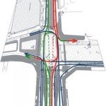
 The project has already been partially realised ‘with the installation of a Jersey barrier reproducing the central ring of the circulation system as roundabout.’ The conflict at the intersections is that even if four main axes concur, the asset of the geometries of approaches determine the definition of 11 traffic flows (five in entry – A1, A3, C1, B1, D1, and six in exit – A2, A4, C2, B2, B4, D2).
The system of breakdown of the main flow (highway) overlaps with the local one (blue lines). The solution adopted for VUs can create conflict points with great intensity due to the incidence of the flows that remain on the highway itinerary (red to Pune; green from Pune to north) with the local flows. Moreover, signalling devices to slow down the flow on the highway approaching the pedestrian crossings are not present.
In all, the conflict scheme shows seven main conflict points with the number of branches/flows entering and exiting for each point. While higher intensity is located in A1-C2, the two pedestrian crossings on A1 and C2 pose high risk of accidents (in the case of equal flows), followed by D1-A2; C1-B4; and B1.
 The pedestrian routes are developed with continuity and cover the entire development of the perimetric circuit of the intersection. The protection devices for pedestrians, according to the audit, consist essentially of ‘specific localisation of crossing points’ and ‘protection with metallic railing to canalise the pedestrian flows on specific itineraries’. For the users of two wheelers, cyclists in particular, dedicated itineraries and routes are not planned, thus assuming as transit way the same carriageway as used by the vehicles.
Intersection geometry
Absence of double deflection: It has been recommended to organise the traffic by creating a roundabout circuit around a stretched ring (rectangle with rounded edges), with the shorter side oriented in the direction of the highway axe. At present, in the absence of a roundabout, an absence of the slowing down of vehicles in crossing the intersection is noted on certain itineraries like A1-B4; B1-A4; D1-C2 – the drivers of vehicles can maintain high speed without giving any attention to the risk to pedestrians. A roundabout can do away with such conflicts.
Left turning: The ring is either not used or used minimally for left turning for the itineraries C1-B2; A1/A3. In the case of D1-A4 the trajectory is on turning trunk while for D1-A2 the ring is engaged minimally. Such conditions pose great danger for two-wheeler users, particularly cyclists, driving on the slow lane (left). This leads to over-exposing of conflicts between vehicles and pedestrians as the drivers would be induced to resort to ‘cutting and turning’ along the line of the connection arc, posing severe risk to passengers at all the indicated turnings.
Recommendations in RSA
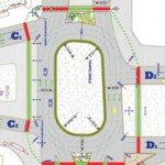
1) Modification of the geometry: The ideal geometry for managing the intersection is a roundabout — giving adequate spaces to realise a perfectly centred roundabout with four axes and with a typical convergence perpendicular to the axes exist.
Refraining from giving a new geometric solution, a possible geometry for the intersection, indicated below:
 2) Standardisation of the approaching axes: Concerning the approach A, the coplanar A1 and A4 should foresee entrance and exit from the roundabout along the axe A by means of input trunks and slides at a distance not lower than 300 metres from the ring external to the roundabout. Thus, the flows from, and for, the highways from these coplanar do not engage the intersection. Eventually left turning lanes A-C; D-A; B-D and C-B can be planned for local movements going external to the roundabouts to further lighten the conflict intensity for the pedestrian crossings.
3) Rationalisation of the pedestrian circuit: The pedestrian crossings located on the approaching trunks with this configuration bring to a reduction of stretches exposed, and to a great reduction of the pedestrian circuit exposed, to vehicular conflicts around the intersection area. Eventually it is possible to plan the realisation of islands for pedestrians in correspondence of the roundabout trunks to guarantee an easy interruption of crossings.
4) Reduction of conflicts: There is a general reduction of the number and intensity of conflicts both between the motorised users and for the vulnerable users. The proximity of the points of access/egress of each trunk induces a uniformity of movement in the ring improving the safety conditions, as it reduces unexpected behaviour of drivers.
5) Reduction of speed: The crossing and approaching speeds are greatly reduced by the imposition of the trajectory of double deflection and this represents one of the best benefits of the roundabout in addition to the fact of guarantying minimal crossing times for all the itineraries.
6) Improvement of visibility: The visibility is greatly improved and also the reciprocal perception of flows that engage the intersection.
7) Easy cycling insertion: It is easy to insert an external ring having the functions of cycling path guarantying to these users crossing safely.
